


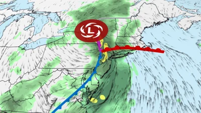
The Northeast — including the New York City metropolitan area — is facing a potentially significant flash flood threat this week from an unusually strong storm that could drop up to a month’s worth of rain in just a few days.
The soaking system will be spawned by a pocket of energy that’s firing up severe thunderstorms in parts of the Great Lakes and Ohio Valley on Monday. The primary threat is powerful wind gusts, which could knock out power and down trees, but isolated tornadoes are possible. One extremely dangerous and destructive tornado hit northeast Wisconsin Monday afternoon.
Tuesday, the storm will spin its way into the Northeast, where it will intensify and slow down dramatically. It’s expected to linger over parts of the region through at least Thursday, dumping way too much rain.
The storm’s strength when it’s over central New York on Wednesday will be more on par with a system we’d expect to see in October, November or December — not late July. Storms are usually weaker in summer than winter because the jet stream doesn’t add as much punch to intensify them.
At the same time, the system will tap into souped-up, moisture-rich pipelines of Atlantic and Gulf air. The amount of water vapor in this air mass will reach levels well above average for even midsummer’s humid reputation.
Those extreme opposites will clash and cause multiple rounds of heavy rain and thunderstorms to flourish over the Northeast.
Monday brought an ominous preview in northern New Jersey, even before the main storm arrived. A slow-moving thunderstorm dumped over 3 inches of rain near Glen Rock and Ridgewood, according to radar estimates, flooding highways and streets across parts of Bergen and Passaic counties.
Video from Glen Rock showed a BMW nearly submerged. Two people trapped inside escaped before police arrived, but the water was initially too deep for a tow truck to reach the vehicle. Numerous water rescues were reported around Glen Rock, Hawthorne and Fair Lawn, New Jersey.
This was not even the main event. Monday’s flooding came from a localized thunderstorm ahead of the larger storm expected to bring a more widespread flood threat beginning Tuesday. Parts of the region are already saturated and increasingly vulnerable to additional flooding.
The New York Tri-state area, from northern New Jersey to western Connecticut, has the biggest risk of flooding rain on Tuesday and Tuesday night, but a localized threat covers most other parts of the Northeast.
A round of rainfall from eastern New York to Pennsylvania in the morning will likely be followed by additional bouts in the afternoon and evening. The heaviest storms could produce rainfall rates of up to two inches per hour.
Urban and poor drainage areas are likely to have the biggest flooding concern and some areas could see significant impacts that may rise to a more serious level as it has multiple times across the United States this month, including in New York City on July 18, according to the National Weather Service.
Flash flooding is one of the deadliest weather hazards and is particularly dangerous in urban settings. Dozens were killed nearly five years ago in the Northeast when Hurricane Ida dumped 7 to 10 inches across a similar corridor that faces a threat this week.
Farther south, severe thunderstorms are a threat on Tuesday from around Washington, DC, to North Carolina. Wind damage is the primary concern from any storms that intensify.
The most expansive flash flood threat will shift a bit farther north on Wednesday into southern New England, including Boston and Hartford, but New York City will also remain at risk.
Downpours will likely be ongoing across this area as the day begins. Flash flooding could unfold as one or more narrow bands of heavy rain spread northeastward through the afternoon. New storms could form behind this area as well.
At least scattered flash flooding impacts are possible, especially in urban and poor drainage areas, the National Weather Service in Boston said. Travel delays are likely at airports and on roads throughout the region.
Pockets of heavy rainfall could persist in parts of the Northeast on Thursday, but it’s too soon to pinpoint any specific flooding concerns.
Much of the Northeast flood threat area will pick up 1 to 4 inches of rainfall through Thursday. Locally, some areas could see 6 inches or more.
Higher amounts are possible in locations that are hit with several rounds of rain, and in spots where bands of rain slow down or stall out for multiple hours, leading to more serious flooding impacts.
The storm will weaken and push out of the Northeast on Friday, but a few scattered showers and storms could still billow up over the region.
CNN’s Amanda Jackson contributed to this report.
Have any thoughts?
Share your reaction or leave a quick response — we’d love to hear what you think!
-
 0
0
-
 0
0
-
 0
0
-
 0
0
-
 0
0
-
 0
0