


An early fall nor’easter is beginning to take shape and over the next few days it will make a beeline for Massachusetts.
The WBZ Weather Team has issued a NEXT Weather Alert for heavy rain, strong wind and coastal concerns in the forecast for the Boston area this weekend.
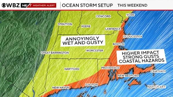
In general, the highest impacts from this storm will be felt along the coastline and over southeastern Massachusetts. If you live well away from the coast, this will likely come as more of a weekend annoyance with less overall impact.
Nor’easter timeline
This is going to be a long and drawn-out affair with more than 72 hours between the first drop and last drop of rain.
The rain will arrive over extreme southeastern Massachusetts Friday evening and overnight.
The first band of heavy rain will then pivot north and west during Saturday morning, eventually enveloping most of southern New England.
From there, we are in the soup for the weekend.
There will be bands of rain with varying intensity throughout Sunday and well into Monday.
The center of the storm will slow to a crawl and perhaps even back in toward the Massachusetts coastline.
The intensity of the rain and wind will diminish late in the day on Sunday and continue to do so during Monday.
We should see a complete end to the storm by Monday evening/overnight.
Rain and flooding
We expect most of the area to receive between 1 and 3 inches of rain from the nor’easter. The highest amounts will be closer to the coast and over southeastern Massachusetts.
The lower amounts will be west of Interstate 95 and well inland.
There could be some isolated rainfall totals between 3 and 6 inches, again the best chance of this would be in far eastern areas.
Given the recent drought status, the area can certainly soak up a few inches of water. The trouble comes if we get heavy amounts in a short period of time. So, we will watch for some localized street flooding but do not expect any major river flooding.
High Wind Watch
The National Weather Service has issued a High Wind Watch for coastal areas Friday and Saturday.
We expect northeast wind gusts to peak between 50 and 70 mph over Cape Ann, Cape Cod and the islands this weekend.
For the rest of the coast, we are forecasting 40-to-55 mph gusts.
West of I-95, less impactful winds in the neighborhood of 30-to-40 mph at worst.
The winds will be at their worst Friday night through Saturday night and then slowly will taper and shift direction during Sunday and beyond.
There is a decent chance of some scattered power outages where the winds will be strongest (again, along the immediate coast and the Cape and Islands).
This would likely coincide with the timing of peak winds late Friday through late Saturday.
Have any thoughts?
Share your reaction or leave a quick response — we’d love to hear what you think!
-
 0
0
-
 0
0
-
 0
0
-
 0
0
-
 0
0
-
 0
0